9 Best Free GPX Creator Software For Windows
Here is a list of Best Free GPX Creator Software For Windows. A GPX (GPS Exchange Format) file stores GPS data containing waypoints, routes, and tracks. These freeware let you create GPX files or even edit existing ones. The procedure to create GPX files in all these is almost similar. You first need to add several waypoints and then create routes joining them. Many of these provide flexibility to add waypoints manually or use the map to locate waypoints. You can manually edit waypoint, track, and route’s properties such as name, coordinates, elevation, depth, symbol, proximity, temperature, contact information, web link, file link, references, etc.
Additional tools provided in some of these GPX creator software include Compress Tracks, Merge Tracks, Select Waypoints By Symbol, Change Selected Waypoints, Insert Map Image, Select Waypoints Far From Routes, Tracklog Reducer, Create Waypoints from Trackpoints, Break/Join Tracks, Mark/Unmark Waypoints, etc.
Apart from GPX, many of these support other file formats like KML, CSV, XLS, GPI, LOC, TCX, etc. too.
My Favorite GPX Creator Software For Windows:
Garmin BaseCamp is a nice GPX generator for Windows. It comes with basic as well as advanced set of tools to create GPX files. If you want a simple and easy to use GPX creator, go for Extra POI Editor.
You may also like some best free GIS Software, Geotagging Software, Track Designer Software, and Picture Location Finder Software for Windows.
Garmin BaseCamp
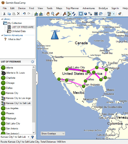
Garmin BaseCamp is a popular and feature rich GIS software. Using it, you can also edit GPX files or even create GPX files.
How to create GPX files in Garmin BaseCamp:
In order to create a new GPX file, follow these simple steps:
- Go to File > New > List and create a new list.
- Now from Tools menu, you can create new waypoints, tracks, and routes in the created list. These components are created using 2D or 3D map.
- All added points, routes, and tracks are accessible from left panel. From there, you can manually edit their properties. For example, for a waypoint, you can enter its name, coordinates, elevation, depth, symbol, proximity, temperature, contact information, web link, file link, references, etc. As for routes, you can add an activity profile (Driving, Hiking, Bicycling, Direct, RV, etc.), route directions, etc.
- You can also select multiple waypoints and create a new route using them.
- As you finish creating a GPX file, you can export it using File > Export option. Apart from GPX, it supports KML, KMZ, LOC, TCX, etc. formats too.
It is one of the best GPX creator software in my opinion. It also provides some other useful tools including Send File to Device, Find Points of Interest, Trip Planner, etc.
GPS Utility
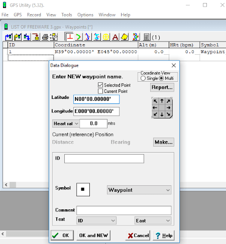
GPS Utility is an easy-to-use GPX creator for Windows. To create GPX files, click File > New option and then add waypoints from its interface. While adding a waypoint, you need to specify its coordinates, altitude, type, ID, symbol, direction, etc. Also, you can create routes and trackpoints individually and add track summary. A dedicated Tools menu is provided to compress tracks, expand tracks, join all, chart tracks, calibrate altitude/depth, etc. Additionally, you can create waypoints from trackpoints, break/join tracks, mark/unmark waypoints, and more. Several view modes, map customization options, unit customization, GPS features, etc. are available in it.
After creating waypoints, routes, and tracks, you can export the file in GPX format using File menu. It supports a wide range of file formats to store the create GPS information, such as TXT, CSV, TCX, KML, WPT, etc.
All in all, it is a nice GPX creator with easy GUI.
Note: The free version of this software doesn’t let you edit existing GPX file. You need to buy its pro version in order to fully utilize it.
Extra POI Editor

Extra POI Editor is the easiest software to create GPX files. You can also edit an existing GPX file in it. It supports other file formats for the same, such as KML, CSV, XLS, GPI, etc.
In order create GPX file, follow these two steps:
- First, using Add New POI button, create new waypoints with their coordinates. To locate a waypoint, you can use the global map. Other than that, you can manually add elevation, time, contact information, display preferences, tour guide information, etc. information.
- Second, go to File > Save As and save created GPS data as a GPX file.
Simple, isn’t it? Similarly, you can edit GPX file too. It provides some useful tools which are:
- Merge Open: To simply merge two or more GPX files.
- Batch Replace: To batch replace a particular field value in all points.
- Street Map View: You can view points in a street map view.
- Batch Geocoding and Batch Reverse Geocoding are some other features.
GPS TrackMaker
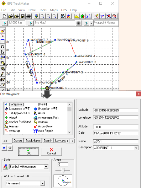
GPS TrackMaker is another nice free GPX creator for Windows. The procedure to create GPX files in it is similar to that of other listed software. You first need to add multiple waypoints and then create routes and tracks using them. Below is the simplified procedure of how exactly to create a GPX file using it.
A quick tutorial to create GPX files in GPS TrackMaker:
- Firstly, choose Pencil tool from Draw menu or the quickly accessible toolbar on interface. This tool helps you draw waypoints on the plane.
- After inserting waypoints, you can select it and edit related properties such as symbol, coordinates, altitude, name, description, etc.
- Now, from Draw menu, you can create routes using added waypoints. Additionally, you can draw continuous lines, polygons, handsfree drawing, etc.
- Some other useful tools provided in it include Select Waypoints By Symbol, Change Selected Waypoints, Insert Map Image, Select Waypoints Far From Routes, Tracklog Reducer, etc.
- At last, you can save the created file in GPX format.
GPS TrackMaker is one of the easiest software to create GPX files. It can be used with various GPS devices for different services. You can know more about it on its official website.
GpsPrune
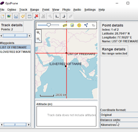
GpsPrune is a free, portable GPX creator for Windows. To start creating a GPX file, go to Points menu and enter new coordinates to create a waypoint. Similarly, you can add several waypoints to create a track. You can also create a series of waypoints. Later, you can edit waypoint information including time, segment, description, and type. Other options that you can use include delete points, duplicate points, rearrange waypoints, sew track segments together, etc.
It provides a Compress Track option to remove duplicate points, wacky points, nearby point, etc. Some other tools provided in it are coordinate format and distance unit preference, set start and end range, estimate time, full range detail, etc. You can view the waypoints on a simple plane or on the global map.
Apart from GPX, its other supported formats include KML, POV, SVG, Text, and Image files.
All in all, it is a simple yet effective software to create GPX files.
JGPSTrackEdit
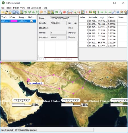
JGPSTrackEdit is a portable GPX creator and editor software for Windows. It lets you create Garmin GPX Track files by creating points and tracks.
At first, go to Track menu and add a new track with its name. Now, you can add points on given map to create a track. The points can be added in Append or Append Routing mode. All added points will be visible in a separate section of the interface. For more accuracy, you can manually edit their coordinates, elevation, and timestamp. As you create a track, its estimated length, duration, driving time, etc. are shown in the middle panel. Similarly, you can add more tracks to the create file.
Some useful features of this GPX creator software:
- It lets you move or delete a waypoint.
- You can reverse tracks, split tracks, merge tracks, compress points, correct points, remove invalid points, etc.
- You can change the map view to any of OpenStreetMap, OpenCycleMap, HikeBikeMap, MapQuest (Satellite), etc.
- You can view coordinates, point information, distance measurement, etc.
- Apart from GPX format, you can export the created file as KML, ASC, PNG, etc. file.
Viking
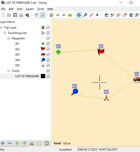
Viking is one more software in this list to create GPX files.
How to create GPX files in Viking:
Go to Layers menu and select New TrackWaypoint Layer option. You can add this layer by configuring basic properties of waypoints, tracks, etc., such as color, size, marker, etc. You can now create waypoints, tracks, and routes from Tools menu. Later, you can edit respective properties too. It lets you add multiple layers to created file including Aggregate, Coordinate, GeoRef Map, GPS, Map, and DEM layers.
To save created file as a GPX file, use Export All option from File menu. Other than GPX, it supports KML file format. You can even export map view of created GPX file as an image.
Viking is a nice GPX creator and editor. It also provides a handy tool to geotag a JPEG image using a waypoint.
EasyGPS
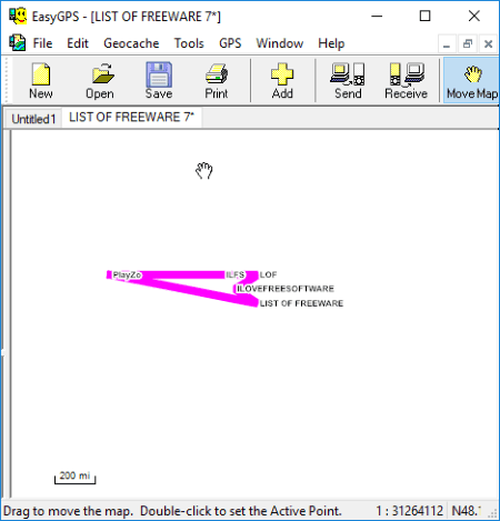
EasyGPS is the next GPX creator software for Windows in this list. It is quite simple to create GPX files using this software. You can start with adding waypoints with respective information such as coordinates, symbol, label, etc. It also lets you receive waypoint from GPS. After creating waypoints, you can create routes and tracks. It shows the added waypoints, routes, and tracks on the map.
It also lets you import and edit GPX files by modifying waypoints, tracks, and routes. You can simply save the file after creating or editing GPX file.
ITN Converter
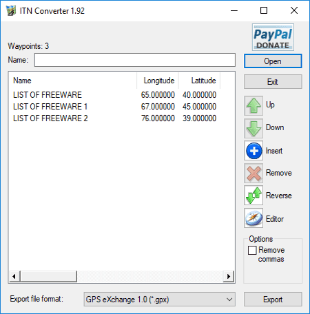
ITN Converter is a simple GPX creator for Windows. Although it mainly converts supported file formats, you can also create GPX files using it. The procedure is quite simple. Just insert waypoints in a sequence to create a route. You first need to manually add waypoint information like latitude, longitude, elevation, name, and comment. You can move points, reverse the order of points, or remove points.
An Editor tool provided in it is really useful. It lets you located added points on the global map. From here, you can even move a point to another location. Also, it provided Get Directions, Show entire itinerary, choose a desired map view, etc. features.
After creating the file, select GPX as output format and hit the Export button. Other supported formats include KML, RTE, XML, ITF, etc.
About Us
We are the team behind some of the most popular tech blogs, like: I LoveFree Software and Windows 8 Freeware.
More About UsArchives
- May 2024
- April 2024
- March 2024
- February 2024
- January 2024
- December 2023
- November 2023
- October 2023
- September 2023
- August 2023
- July 2023
- June 2023
- May 2023
- April 2023
- March 2023
- February 2023
- January 2023
- December 2022
- November 2022
- October 2022
- September 2022
- August 2022
- July 2022
- June 2022
- May 2022
- April 2022
- March 2022
- February 2022
- January 2022
- December 2021
- November 2021
- October 2021
- September 2021
- August 2021
- July 2021
- June 2021
- May 2021
- April 2021
- March 2021
- February 2021
- January 2021
- December 2020
- November 2020
- October 2020
- September 2020
- August 2020
- July 2020
- June 2020
- May 2020
- April 2020
- March 2020
- February 2020
- January 2020
- December 2019
- November 2019
- October 2019
- September 2019
- August 2019
- July 2019
- June 2019
- May 2019
- April 2019
- March 2019
- February 2019
- January 2019
- December 2018
- November 2018
- October 2018
- September 2018
- August 2018
- July 2018
- June 2018
- May 2018
- April 2018
- March 2018
- February 2018
- January 2018
- December 2017
- November 2017
- October 2017
- September 2017
- August 2017
- July 2017
- June 2017
- May 2017
- April 2017
- March 2017
- February 2017
- January 2017
- December 2016
- November 2016
- October 2016
- September 2016
- August 2016
- July 2016
- June 2016
- May 2016
- April 2016
- March 2016
- February 2016
- January 2016
- December 2015
- November 2015
- October 2015
- September 2015
- August 2015
- July 2015
- June 2015
- May 2015
- April 2015
- March 2015
- February 2015
- January 2015
- December 2014
- November 2014
- October 2014
- September 2014
- August 2014
- July 2014
- June 2014
- May 2014
- April 2014
- March 2014
